Description
Struve geodetic arc is part of the history of science and technology. It’s an UNESCO World Heritage feature that’s located in ten countries stretching from Arctic Ocean to Black Ocean. The countries are Norway, Sweden, Finland, Russia, Estonia, Latvia, Lithuania, Belarus, Moldova and Ukraine. German-born Russian scientist Friedrich Georg Wilhelm von Struve used it during 1816 – 1855 to determine the Earth’s size and shape using triangulation. The arc had 265 measurement points spanning over 2800 km. 34 of them are UNESCO protected sites since 2005. Six of them are located in Finland, one of them in Oravivuori, at coordinates 61°55’36″N 25°32’01″E.
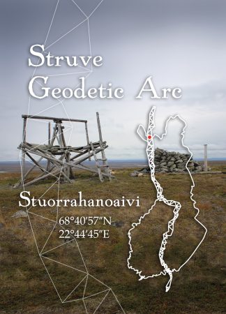
Stuorrahanoaivi is a fell in northwestern Lapland, close to the Norwegian border in the Tarvantovaara wilderness area. The hike from road to fell is challenging. The route is not marked and in summer, visiting the measuring point takes 2-5 days. In winter, the snowmobile trail is about three kilometers away, but you are not allowed deviate from the route to the point without permission or a local guide. The coordinates of the northernmost measuring point in Finland are 68 ° 40′57 ″ N, 22 ° 44′45 ″ E.
Visiting this measuring point requires an experienced wilderness hiker and so Jyrki Puupponen has taken the card’s photo.